Definition: An altimeter is a scientific instrument designed to measure the altitude of an object or location above a fixed reference point, typically mean sea level (MSL) or ground level (AGL, Above Ground Level). It is widely used in aviation, aerospace, mountaineering, and meteorology to determine vertical position.
Core Working Principles
Altimeters operate based on two primary physical principles, with variations for different use cases:
- Barometric AltimetryThis is the most common type, relying on the relationship between atmospheric pressure and altitude: atmospheric pressure decreases as altitude increases.
- A barometric altimeter contains a pressure sensor (aneroid barometer) that measures ambient air pressure.
- It converts pressure readings into altitude values using a standardized atmospheric model (e.g., the International Standard Atmosphere, ISA).
- Critical Note: Barometric altimeters require calibration to a reference pressure (e.g., QNH for mean sea level, QFE for ground level) because weather changes alter atmospheric pressure and affect accuracy.
- Radio/Radar AltimetryUsed for precise measurements of height above the immediate ground surface (AGL), this type emits radio waves and calculates altitude based on the time it takes for the signal to reflect off the ground and return to the sensor.
- Common in aircraft during landing phases, as it provides real-time, terrain-referenced altitude data independent of atmospheric conditions.
- Also applied in satellite altimetry (e.g., for ocean surface mapping) to measure distances between the satellite and Earth’s surface.
- GNSS AltimetryLeverages Global Navigation Satellite Systems (GNSS, e.g., GPS, Galileo) to compute altitude by triangulating signals from multiple satellites.
- Offers global coverage but has lower precision (typically ±1–5 meters for consumer devices, higher for professional systems) compared to radar altimeters.
- Widely integrated into smartphones, drones, and hiking watches for consumer and light industrial use.
Key Types & Applications
| Type | Primary Use Case | Key Features |
|---|---|---|
| Barometric Altimeter | Aviation (commercial/GA aircraft), mountaineering, hiking watches | Lightweight, low power; requires pressure calibration; affected by weather |
| Radar Altimeter | Aircraft landing, helicopter operations, military aviation | High AGL precision (±0.1–1 meters); immune to atmospheric interference |
| GNSS Altimeter | Consumer drones, smartphones, outdoor recreation | No calibration needed; global coverage; moderate accuracy |
| Laser Altimeter (LiDAR) | Satellite mapping, topographic surveying, autonomous vehicles | Ultra-high precision; uses laser pulses to measure distance; ideal for terrain modeling |
Industrial & Professional Applications
- Aviation: The most critical application—pilots use barometric altimeters to maintain safe vertical separation from other aircraft and terrain. Commercial jets combine barometric and radar altimeters for takeoff, cruise, and landing phases.
- Aerospace: Satellites use laser or radar altimeters to map Earth’s topography, monitor sea level rise, and study planetary surfaces (e.g., Mars rovers use altimeters for navigation).
- Meteorology: Used in weather balloons to measure pressure and altitude profiles of the atmosphere, aiding in weather forecasting.
- Mountaineering & Hiking: Compact barometric altimeters in watches help climbers track their elevation above sea level and predict weather changes based on pressure trends.
- Drones & UAVs: GNSS and barometric altimeters ensure stable flight by maintaining a fixed altitude; professional drones may add radar altimeters for precision landing in complex terrain.
Technical Specifications & Limitations
Radar altimeters have limited maximum range (typically up to 10,000 meters) and are ineffective over water or flat, featureless terrain.
Accuracy: Varies by type—barometric altimeters have an accuracy of ±10–50 meters (calibrated), radar altimeters ±0.1–1 meters (short-range), and consumer GNSS altimeters ±1–5 meters.
Limitations:
Barometric altimeters are sensitive to weather changes (e.g., low-pressure systems can cause incorrect altitude readings if not recalibrated).
GNSS altimeters perform poorly in dense forests or urban canyons where satellite signals are blocked.
- 10AWG Tinned Copper Solar Battery Cables
- NEMA 5-15P to Powercon Extension Cable Overview
- Dual Port USB 3.0 Adapter for Optimal Speed
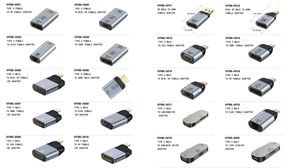
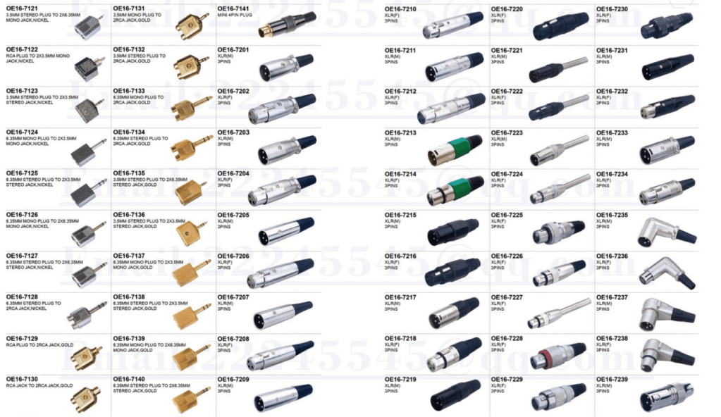
- 4-Pin XLR Connector: Reliable Audio Transmission
- 4mm Banana to 2mm Pin Connector: Your Audio Solution
- 12GB/s Mini SAS to U.2 NVMe Cable for Fast Data Transfer
- CAB-STK-E Stacking Cable: 40Gbps Performance
- High-Performance CAB-STK-E Stacking Cable Explained
- Best 10M OS2 LC to LC Fiber Patch Cable for Data Centers
- Mini SAS HD Cable: Boost Data Transfer at 12 Gbps
- Multi Rate SFP+: Enhance Your Network Speed
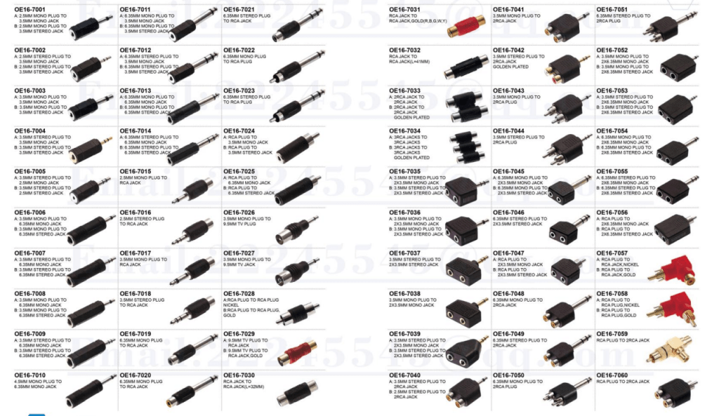
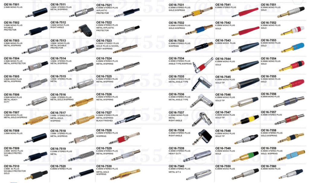
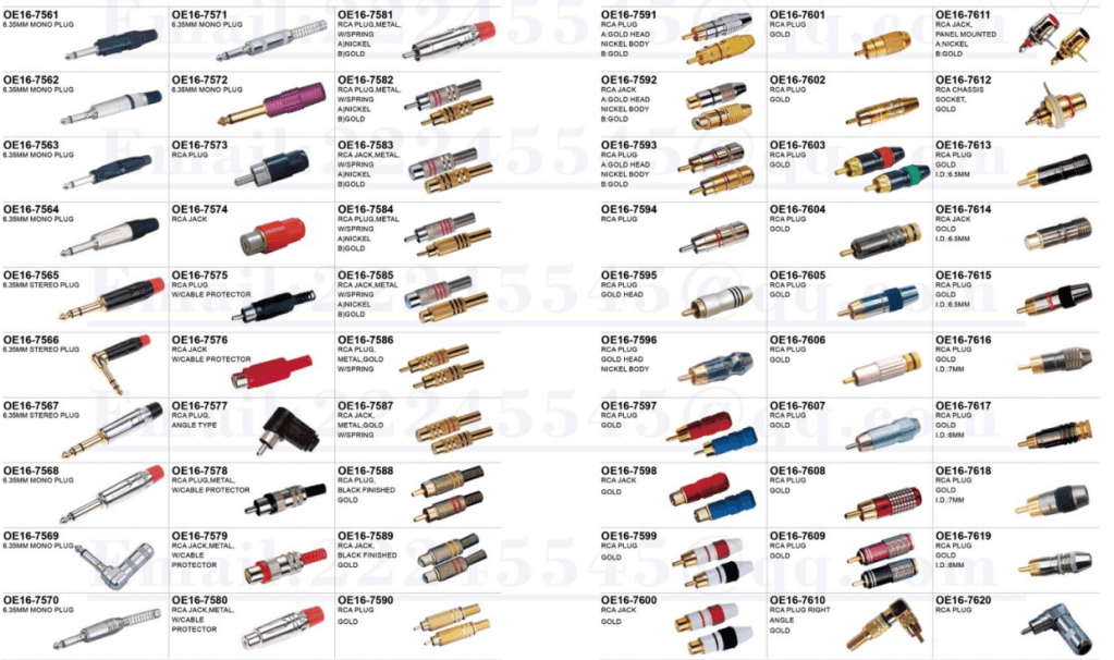
- Best 6.35mm to MIDI Din Cable for Clear Sound
- 15 Pin SATA Power Splitter: Solutions for Your Device Needs
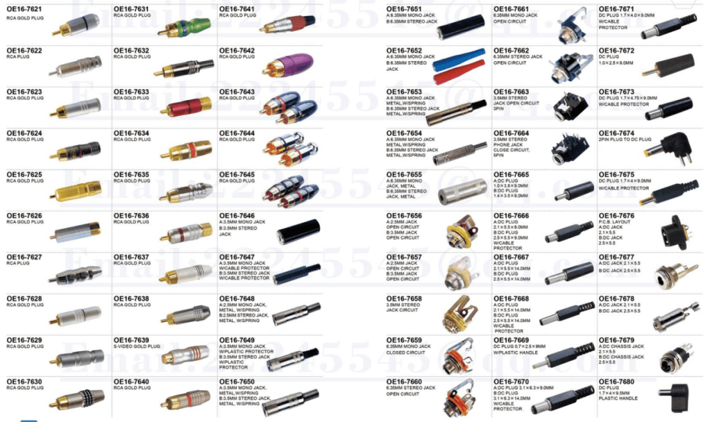
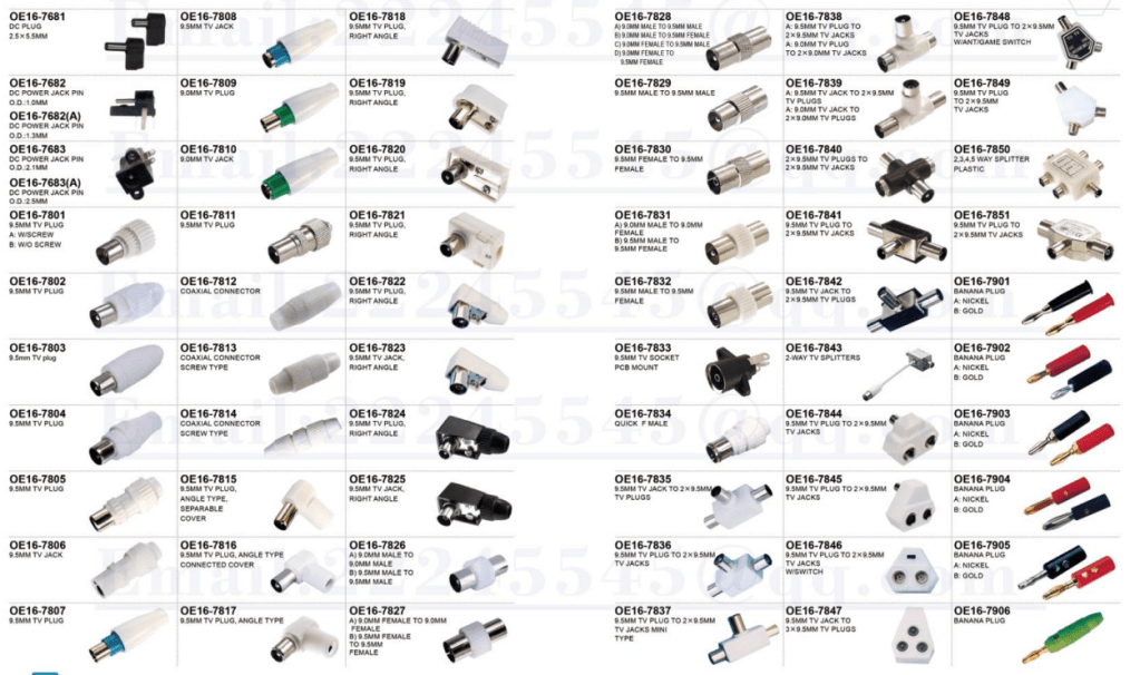
- 9-Pin S-Video Cable: Enhance Your Viewing Experience
- USB 9-Pin to Standard USB 2.0 Adapter: Easy Connection
- 3 Pin to 4 Pin Fan Adapter: Optimize Your PC Cooling
- S-Video to RCA Cable: High-Definition Connections Made Easy
- 6.35mm TS Extension Cable: High-Quality Sound Solution
- BlackBerry Curve 9360: Key Features and Specs
- BlackBerry Curve 9380: The First All-Touch Model
- BlackBerry Bold 9000 Review: Iconic 2008 Business Smartphone
- BlackBerry Bold 9700 Review: Specs & Features
- BlackBerry Bold 9780: The Ultimate Business Smartphone


Leave a comment