Laser Scanning
Definition: Laser scanning is a non-contact measurement technology that uses laser beams to capture the shape, position, and surface details of objects or environments in 2D or 3D. It works by emitting laser pulses (or continuous laser beams) onto a target, measuring the time-of-flight (ToF) or phase shift of the reflected light, and reconstructing a digital model (point cloud) of the target with high precision.
Laser scanning is used across industries such as manufacturing, construction, archaeology, automotive, and healthcare for tasks like quality control, reverse engineering, surveying, and 3D modeling.
Core Working Principles
Laser scanners operate based on two primary measurement methods, plus a hybrid approach:
1. Time-of-Flight (ToF) Laser Scanning
- Mechanism: The scanner emits a short laser pulse and measures the time it takes for the pulse to travel to the target and reflect back to the scanner’s receiver.
- Calculation: Distance (d) is computed using \(d = \frac{c \times t}{2}\), where c = speed of light (\(3 \times 10^8\) m/s) and t = round-trip time of the pulse.
- Key Features:
- Long-range capability (up to several kilometers for terrestrial scanners).
- Works well for outdoor environments (e.g., topographic surveying, building scanning).
- Lower resolution than phase-shift scanning but ideal for large-scale targets.
2. Phase-Shift Laser Scanning
- Mechanism: The scanner emits a continuous, modulated laser beam (e.g., sinusoidal wave) and measures the phase difference between the emitted and reflected beams.
- Calculation: Phase shift (\(\phi\)) is proportional to the distance to the target: \(d = \frac{\lambda \times \phi}{4\pi}\), where \(\lambda\) = wavelength of the modulated beam.
- Key Features:
- High precision (sub-millimeter accuracy) for short-to-medium ranges (up to 100m).
- Fast data acquisition (millions of points per second).
- Ideal for indoor scanning, reverse engineering, and quality control of small-to-medium objects.
3. Triangulation Laser Scanning
- Mechanism: A laser beam is projected onto the target, and a camera (offset from the laser source) captures the position of the reflected laser spot. Distance is calculated using triangulation (geometry of the laser-camera setup).
- Key Features:
- Ultra-high precision (micron-level resolution) for very short ranges (up to 1m).
- Used for detailed surface scanning (e.g., microchip inspection, dental modeling).
- Limited by field of view (best for small objects).
Types of Laser Scanners
Laser scanners are categorized by their design, mobility, and application:
1. Terrestrial Laser Scanners (TLS)
- Form Factor: Stationary, tripod-mounted scanners for large-scale outdoor/indoor environments.
- Use Cases:
- Construction: As-built documentation of buildings, bridge inspection, and site mapping.
- Archaeology: 3D modeling of historical sites or artifacts without physical contact.
- Mining: Volume calculation of stockpiles, terrain mapping.
- Examples: Faro Focus, Leica ScanStation, Trimble TX8.
2. Mobile Laser Scanners (MLS)
- Form Factor: Mounted on vehicles (cars, drones, trains) or carried by users (backpack scanners) for dynamic scanning.
- Use Cases:
- Transportation: Roadway mapping, railway track inspection, airport runway scanning.
- Urban Planning: 3D city modeling (digital twins), infrastructure monitoring.
- Agriculture: Crop field mapping, canopy height measurement.
- Examples: Velodyne LiDAR (for autonomous vehicles), GeoSLAM ZEB (backpack scanner), DJI Zenmuse L1 (drone-mounted).
3. Industrial Laser Scanners
- Form Factor: Fixed or robotic arm-mounted scanners for manufacturing and quality control.
- Use Cases:
- Reverse Engineering: Creating 3D CAD models from physical parts (e.g., legacy machinery).
- Quality Inspection: Comparing scanned parts to CAD models to detect defects (dimensional accuracy).
- Additive Manufacturing: Scanning parts post-3D printing to verify print quality.
- Examples: Zeiss COMET, Artec Eva (handheld), Nikon Metrology Laser Scanner.
4. Airborne Laser Scanning (ALS / LiDAR)
- Form Factor: Mounted on aircraft (planes, helicopters) for large-area topographic mapping.
- Use Cases:
- Geography: Terrain modeling, forestry (tree height/volume calculation), flood zone mapping.
- Environmental Science: Glacier monitoring, coastal erosion analysis.
- Examples: RIEGL LMS-Q780, Optech Orion M3.
5. Dental/Medical Laser Scanners
- Form Factor: Compact, intraoral scanners (dental) or full-body scanners (medical).
- Use Cases:
- Dental: 3D modeling of teeth for crowns, bridges, or orthodontic aligners (e.g., Invisalign).
- Medical: Patient-specific implant design, body contour scanning for prosthetics.
- Examples: Itero Element (dental), 3Shape TRIOS, Artec Eva Scan (medical).
Key Components of a Laser Scanner
- Laser Source: Emits the laser beam (e.g., near-infrared for outdoor use, visible red for indoor/industrial).
- Scanner Head: Directs the laser beam across the target (via rotating mirrors or galvanometers for 2D/3D coverage).
- Receiver/Detector: Captures the reflected laser light (e.g., photodiode, avalanche photodiode for low-light detection).
- Inertial Measurement Unit (IMU) / GPS: For mobile/airborne scanners—tracks the scanner’s position and orientation (SLAM: Simultaneous Localization and Mapping).
- Software: Reconstructs raw scan data into a point cloud, then processes it into 3D meshes, CAD models, or visualizations (e.g., CloudCompare, Autodesk Recap, MeshLab).
Point Clouds & Post-Processing
The output of laser scanning is a point cloud—a set of millions/billions of 3D coordinates (\(x, y, z\)) representing the target’s surface. Post-processing steps include:
- Registration: Aligning multiple scans of the same target (from different positions) into a single coordinate system.
- Cleaning: Removing noise (e.g., stray points from dust or reflections) and redundant data.
- Meshing: Converting the point cloud into a 3D polygonal mesh (triangles/quadrilaterals) for visualization or CAD integration.
- Analysis: Measuring distances, volumes, or comparing to CAD models (e.g., deviation analysis for quality control).
Benefits of Laser Scanning
- High Precision & Accuracy: Captures details down to microns (industrial) or millimeters (terrestrial), outperforming traditional measurement tools (e.g., tape measures, total stations).
- Non-Contact Measurement: Eliminates damage to delicate targets (e.g., artifacts, fragile machinery) and enables scanning of hard-to-reach areas.
- Speed: Acquires millions of data points per second, reducing scanning time for large targets (e.g., a building can be scanned in hours vs. days with manual methods).
- Comprehensive Data: Captures the entire surface of a target, not just discrete points—enabling full 3D reconstruction and digital preservation.
- Safety: Reduces human exposure to hazardous environments (e.g., high elevations, radioactive areas) by scanning remotely.
Limitations & Considerations
- Line of Sight: Requires unobstructed access to the target (occlusions, e.g., walls or trees, create gaps in the point cloud).
- Surface Reflectivity: Shiny (e.g., metal) or transparent (e.g., glass) surfaces can reflect laser light away from the scanner, causing data loss (mitigated with anti-reflective sprays).
- Environmental Factors: Outdoor scanning is affected by sunlight (reduces detector sensitivity), rain/fog (scatters laser beams), and wind (causes scanner vibration).
- Data Size: Point clouds can be massive (terabytes for large environments), requiring powerful hardware and software for processing.
- Cost: High-end scanners (e.g., terrestrial or industrial) can cost $50,000–$500,000, though low-cost handheld/drone scanners are increasingly available.
Common Applications by Industry
| Industry | Application | Scanner Type |
|---|---|---|
| Construction | As-built documentation, clash detection, progress tracking | Terrestrial, Mobile |
| Manufacturing | Reverse engineering, quality control, 3D printing validation | Industrial, Robotic Arm-Mounted |
| Archaeology/Cultural Heritage | 3D preservation of artifacts, historical buildings, excavation sites | Terrestrial, Handheld |
| Automotive/Aerospace | Vehicle body scanning, component inspection, aerodynamic modeling | Industrial, Laser Tracker |
| Geography/Environmental Science | Topographic mapping, forestry analysis, flood zone modeling | Airborne LiDAR, Terrestrial |
| Dental/Medical | Intraoral scanning, prosthetic design, surgical planning | Dental Intraoral, Medical 3D Scanners |
Future Trends
Multi-Sensor Fusion: Combining laser scanning with cameras (RGB), thermal sensors, or radar for richer data (e.g., colorized point clouds, thermal mapping).
AI Integration: Machine learning algorithms to automate point cloud cleaning, registration, and object recognition (e.g., identifying pipes/wires in building scans).
Miniaturization: Smaller, low-cost scanners for consumer use (e.g., smartphone-mounted laser scanners for 3D modeling).
Real-Time Processing: Edge computing to process point clouds on-site, reducing reliance on powerful desktop software.
- High-Performance Waterproof Solar Connectors
- Durable IP68 Waterproof Solar Connectors for Outdoor Use
- High-Quality Tinned Copper Material for Durability
- High-Quality Tinned Copper Material for Long Service Life
- Y Branch Parallel Solar Connector for Enhanced Power
- 10AWG Tinned Copper Solar Battery Cables
- NEMA 5-15P to Powercon Extension Cable Overview
- Dual Port USB 3.0 Adapter for Optimal Speed
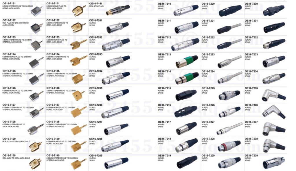
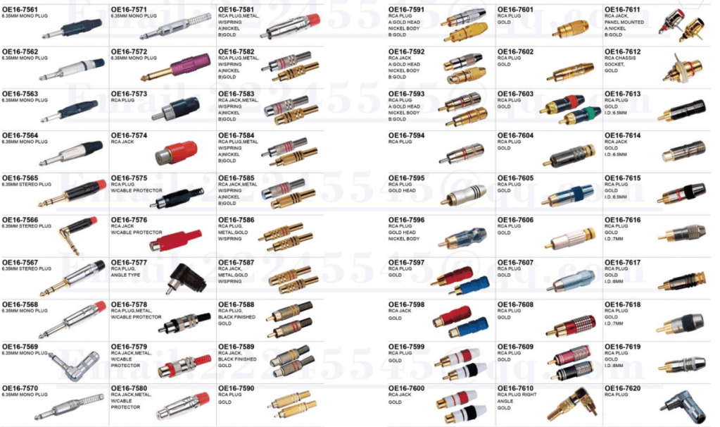
- 4-Pin XLR Connector: Reliable Audio Transmission
- 4mm Banana to 2mm Pin Connector: Your Audio Solution
- 12GB/s Mini SAS to U.2 NVMe Cable for Fast Data Transfer
- CAB-STK-E Stacking Cable: 40Gbps Performance
- High-Performance CAB-STK-E Stacking Cable Explained
- Best 10M OS2 LC to LC Fiber Patch Cable for Data Centers
- Mini SAS HD Cable: Boost Data Transfer at 12 Gbps
- Multi Rate SFP+: Enhance Your Network Speed
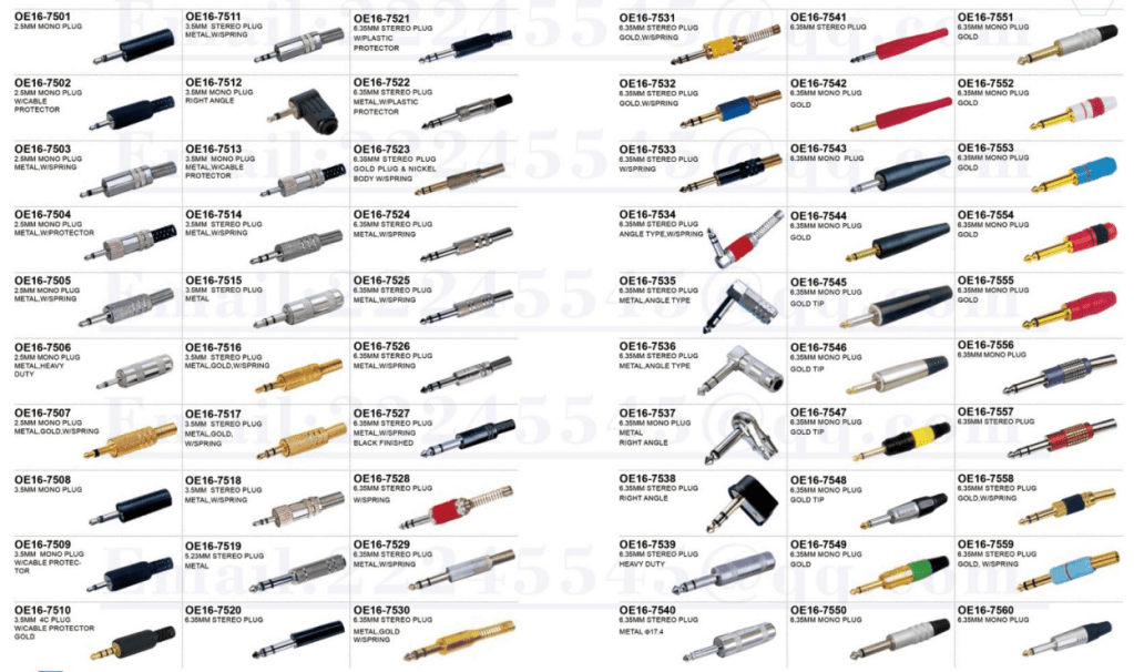
- Best 6.35mm to MIDI Din Cable for Clear Sound
- 15 Pin SATA Power Splitter: Solutions for Your Device Needs
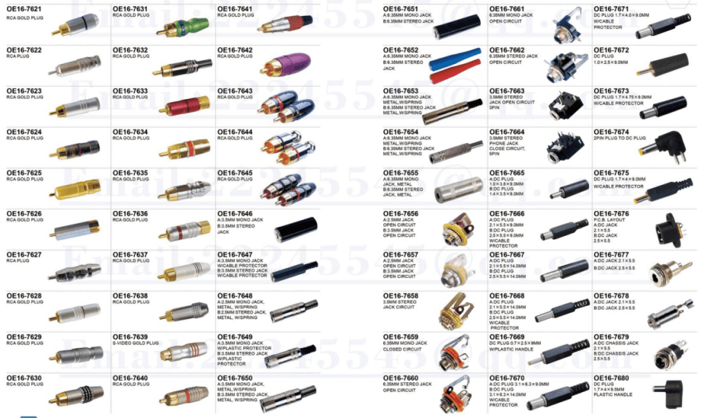
- 9-Pin S-Video Cable: Enhance Your Viewing Experience
- USB 9-Pin to Standard USB 2.0 Adapter: Easy Connection
- 3 Pin to 4 Pin Fan Adapter: Optimize Your PC Cooling
- S-Video to RCA Cable: High-Definition Connections Made Easy
- 6.35mm TS Extension Cable: High-Quality Sound Solution
- BlackBerry Curve 9360: Key Features and Specs


Leave a comment